GlobeDrought Final Workshop
Day 1: Drought & Drought Risk at the Global Scale
Tuesday, 3 November 2020 • 15:00 – 17:00 CET
Purpose of the Workshop
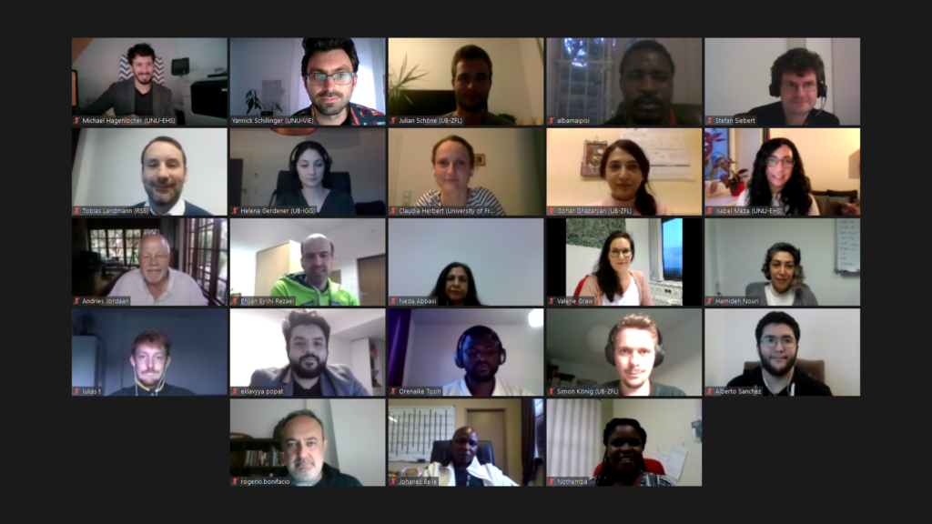
The Final Workshop of the GlobeDrought Project was organised by UNU-EHS as a virtual event on the 3rd and 4th of November 2020, inviting stakeholders from a wide array of organisations to meet with members of the GlobeDrought Consortium. In total, 74 participants registered for the event – out of those, 48 attended on the first day (focus on the global scale) and 32 on the second day (focus on South Africa).
The goals of the workshop were:
- to take stock of pressing policy needs related to droughts as well as of approaches available to characterize, monitor and forecast drought events and associated risks, and to develop policy recommendations,
- to create a common understanding of current knowledge, working being done in the GlobeDrought project (and beyond), and gaps that need to be addressed, and
- develop recommendations for science, practice and policy.
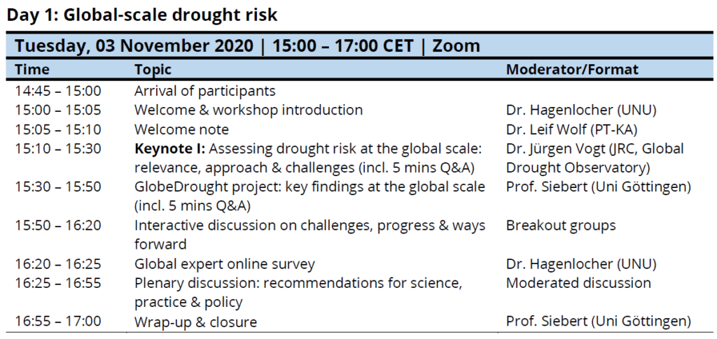
The first day of the workshop was focused on drought and drought risk at the global scale. It started off with welcome notes by Dr. Michael Hagenlocher (UNU-EHS) and Dr. Leif Wolf (PT-KA) providing some background on the project and the workshop.
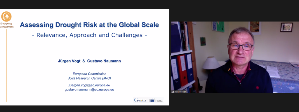
Keynote
The first day’s keynote was given by Dr. Jürgen Vogt (JRC-GDO) about Assessing drought risk at the global scale: relevance, approach & challenges.
Key messages:
- Drought is a hazard that causes significant global impacts: 1.43 billion people affected, 128 billion USD in economic losses (2000-2019)
- Inadequate land and water management practices are a key point where science can take action
- Direct and indirect drought impacts, non-structural and remote impacts depending on exposure and vulnerability → cascading impacts and compound effects
- Drought risk is sector and system specific
- Global Drought Observatory (GDO): early warning, monitoring and forecasting esp. for the Emergency Response Coordination Centre (ERCC)
- GDO home page (open and free): Shows a hierarchical list of affected countries
- Drought as relative statistic resulting in ranking regions and prioritizing actions
- Forecast up to 6 months
- Challenges: High resolution and timely quality meteorological data, standardized impact data, compound effects, adequate weighting of vulnerability data, dynamic risk assessments, among others
- Collaboration GDO and GlobeDrought: Expert survey on vulnerability indicators, UN Disaster Risk Reduction Global Assessment Report (UNDRR GAR) Special Report

Would you have an instructive example, where the drought early warning led to a decision which reduced impact?
One example: impact in Papua-New Guinea, first there were agricultural impacts, then eight organisations had problems with getting to the people because the water lines were not navigable anymore. But then they structured the interventions, got feedback from the people, used local information and made links between users, information was successfully distributed to regional offices and resulted in improved spatial planning; regional offices also gave critical feedback.
If a country would have data on types of crops, is the methodology available for the country to modify it to incorporate this layer?
In principle you can do that, crop specific information, meteorology and soil moisture are relevant for the crop, in principle it’s possible; collaborating with Eastern Africa.
Are you in contact with Climate Risk insurance schemes (thinking of ARC or CCRIF as well as others) which could use your data, especially the forecasts?
No, we don’t have this link directly, we are a small team, open question, system is available publicly, system includes 50 years of global drought events (go through timeline), this can help to assess the risk, but we’re in an unstable climate environment.
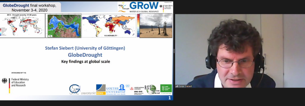
GlobeDrought Presentation
After the keynote, project lead Prof. Stefan Siebert (Uni Göttingen) gave a presentation about GlobeDrought’s key findings at the global scale.
Key messages:
- Drought hazard quantification for rainfed and irrigated systems at global scale
- Drought hazard can well be quantified at global scale, results for specific crops differ across time and space
- Drought impacts are associated with hazard but modulated by distinct vulnerabilities
- Assimilation of GRACE satellite data into the global hydrological model results in more realistic groundwater storage change and streamflow and removes artificial trends
- Global assessment of drought vulnerability together with JRC
- 45 indicators for agricultural systems including proposed weights derived from a survey with 124 international experts
- 25 indicators for agricultural systems quantified for each country and applied in a global drought risk study
- Drought risk computed for the period since 1981
- Highest risk in regions where all risk components (hazard, exposure, vulnerability) are critical
- Considerable spatial differences between drought risk for irrigated and rainfed systems
- Using bias-corrected global ensemble ECMWF forecasts for drought forecasting
- Drought situation in Argentina, Australia and Italy better reproduced with ensemble forecasts
- Severe drouht in Germany outside of the range predicted by historical climate or ensemble forecasts
- GlobeDrought Information System and GlobeDrought eLearning Platform
How is the yearly summary calculated considering that at a global level there are in some countries more than one crop season in a year?
This is considered: for different sub-crops (also seasons and winter crops) we use Mirca2000 dataset and collaborate with other institutions to provide an update, so basically we consider that, we compute data on a monthly timestep.
What is your experience comparing SPI as an index with your ET/PET ratio?
SPI is more a meteorological indicator and region specific (e.g. Amazon), SPI would still show that there’s a drought but there’s little effect on the crop, major patterns are reflected in both, at least in agricultural systems.
Group Discussion
In the following session, the participants split into two groups to brainstorm key gaps, challenges and needs as well as potential recommendations around the topics Early Warning, Early Action and Strengthening Drought Resilience.
GROUP 1 – “Early Warning, Early Action”
What are key gaps, challenges and needs for science-based information to foster enhanced Early Warning Early Action in the context of drought?
- Having accurate data at subnational level, difference in vulnerability of crops, help developing countries getting that data
- Communication, products that we make are understood and used by policy makers, need to know how to use them, clear messaging is important especially regarding early warning and early action, use simple maps with very simple colors
- More impact data to validate the indicators are required
- electronic scanning of newspaper and journals, search by key, soft validation, hard value is often missing
- Teleconnections and temporal differences in rainfed systems can pose difficulties (e. g. pre-mountain areas)
What are potential recommendations for science, practice and policy to ensure risk-informed early warning, early action?
- Clear messages for policy makers
- More look at teleconnections that e.g. droughts in exporting countries can have more severe impacts in importing countries than local droughts
- Put the information from the system into a context: we have a message from the system, what does that mean? Demands from regional offices to put droughts in global contexts
- Accuracy of the forecast is really an issue and needs to be discovered more in detail
GROUP 2 – “Strengthening Drought Resilience”
What are key gaps, challenges and needs for science-based information to enable communities, sectors and countries to strengthen their resilience to droughts?
- Vulnerability assessment: the indicators are not detailed enough and useful enough for communities to react. Local knowledge, specific circumstances should be taken into account
- Vulnerability is not fully understood. Other factors (e.g. management, political, social factors: overgrazing) contribute to drought risk (often not the meteorological conditions) issues of spatial scale issues of past events & how they affect vulnerability. Need to look into root causes, local contexts/factors, include factors that cannot be easily quantified.
- Communication channels – bottom up approach for information transfer from communities, so these communication tools are extremely important
- From global information towards the local adaptation.
- Need for support tools for development of adaptation strategies. Especially challenging for small and medium communities. Gap between scientific evidence and translation of science to action points.
What are potential recommendations for science, practice and policy to ensure that drought resilience strategies and actions are risk-informed?
For science:
- Develop cooperation – To understand what has been done, what has been useful and successful and what not, and bridge between decision makers and local scales using conducted actions
- Understand systemic failures
- use maps for a dialogue with policy (not as an end point) interactive maps, where local communities can contribute / communicate the state and socioeconomic conditions. Up to date and locally proven data should be integrated into the system.
- Moving towards new technologies like remote sensing as a complementary option to drought indices (Andreas)
For practice & policy:
- proactive drought risk management – drought often dealt with responsively, not proactively
- Early warnings are not transferred to grassroot actors not in a timely manner. Transfer the knowledge to farmers/actors based on scientific output.
- extension services as a link/bridge between science and practice/communities
- proactive drought risk management: drought often dealt with responsively, not proactively
- Creation of incentives for local farmers to adopt the adaptation strategies
- Incentives the local communities to use the system, make the local communities voice be heard and reflected in the systems
Take-Home Messages
- Tobias Landmann (RSS): We need to look at risk across sectors and scales for drought risk management and consider the importance of teleconnections
- Drought as a topic is very often located at environmental ministries or institutes but when it comes to a drought it’s a sectoral problem (agro, forestry). Environmental ministries in many development countries are the weakest institutions. They are not really heard / entitled; missing link to “political power”.
- Researchers have to ask themselves: Who are the policy makers in your specific field (importance of communication with the right people on the right terms)
- Oscar Rojas (FAO): We have at a global level information for decision makers for global information systems. At country level you need to go more into detail (crop type, season etc.). Also, automatisation is really important (AI should be used, sensors), inject a forecast, put all these different products together. Furthermore, we have to recognize limitations when we go to early action.
GlobeDrought Final Workshop
Day 2: Drought & Drought Risk in South Africa
Wednesday, 4 November 2020 • 15:00 – 17:00 CET
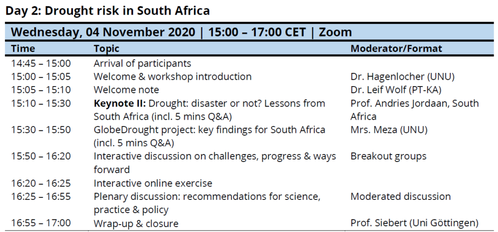
The second day of the workshop was focused on drought and drought risk in South Africa. It started off with welcome notes by Dr. Michael Hagenlocher (UNU-EHS) and Dr. Leif Wolf (PT-KA) providing some background on the project and the workshop.
Keynote
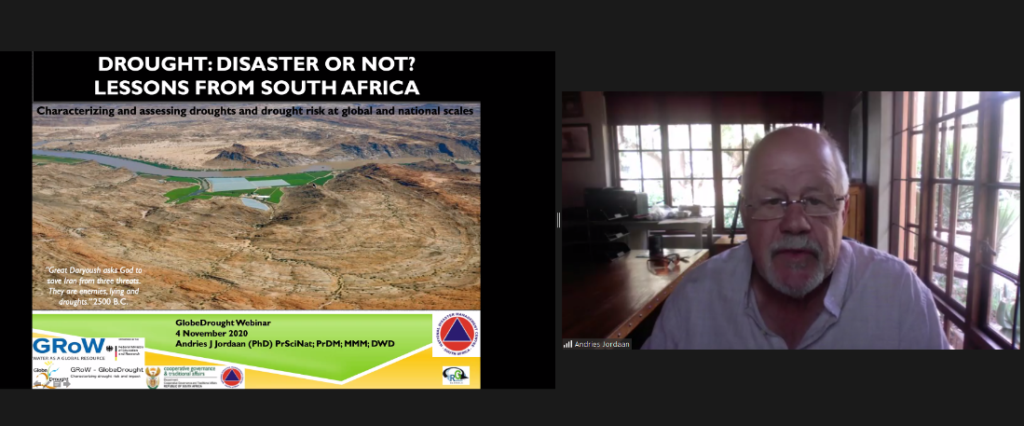
The second day’s keynote was given by Prof. Andries Jordaan (Résilience Globale) about Drought: disaster or not? Lessons from South Africa.
Key messages:
- Day 0 in Cape Town has brought drought and water management practices into the spotlight
- SA has very diverse types of climate (esp. rainfall); rainfall gradient from west to east; very dry and arid country on average
- Climate change expectations until 2050: not a lot of change in rainfall, but high changes in temperature to be expected
- expecting increasing drought tendency esp. in south(western) parts, huge increase in droughts until 2064 also in northern areas (where you can find Kruger national park)
- Population growth might have a bigger impact than climate change dynamicss
- Cannot only be blamed on meteorology but to a large extent on poor (land) planning/management → structural problems in dealing with drought
- At national level drought management is quite well structured: Preventional Joined Drought Coordination Committee; other committees are not so well structured
- What we propose: at national level to establish a drought mitigation unit to work jointly with the coordination team; 24/7 drought monitoring
- Vulnerability indicators are linked to different districts
- (New) spatial units of measurement need to be implemented
- Municipal, province and country level are not sufficient: redefining management units based on catchment areas/boundaries
- Drought in general is part of the South African climate, however support is always too little and too late
- Mitigation plans and other preparation need to be implemented in good (weather) years
- Implement drought contingency plans and drought recovery plans
- The GlobeDrought project is important for us to see what is going on worldwide, e.g. global drought maps or discussions at an international level are very important
Most of the drought classes and monitoring mostly focus on physical conditions. Are there attempts to monitor governmental and social factors?
Yes, we elaborate at municipal capitals, at the moment there are 10 groups of indicators, governance is one, we look at social environment, infrastructure, development.
Quite insightful – my question is on the proposed structure: since there has been funding and operational challenges from the district level or basically lower levels, how this time around in the context of the new structure, can we mitigate those challenges witnessed before?
We try to take out the silo effect on drought management, there are different departments. But the coordination is only taking place through the Joint Drought Coordination Centre which is not enough.
Vulnerability component – based on development of drought management, where do you see a need in science for information?
Difficult to get data, there are some data at local level available, but not sufficient to what we would like to use for drought management, science can contribute a lot through RS indicators and combining data; data is not sufficient for new spatial units (based on catchment areas).
What are projections of drought as it stands? Is it expected to be severe or what?
Settlements in the 17th century were driven by drought, we will experience more severe droughts not just because of the climate impact but because of our impacts (land degradation, population growth, …). Same rainfall is to be expected but other factors play a major role, governance will be very important (e.g. at local level for water distribution).
Drought risk, globally – there is increasing confidence in science (esp. for the higher IPCC scenarios) that drought trends will become more severe, esp. in the second half of the 21th century.
More severe drought mainly based on poor management and too much pressure on available resources in SA; reasonable governance practice will be needed to cope with future droughts.
GlobeDrought Presentation
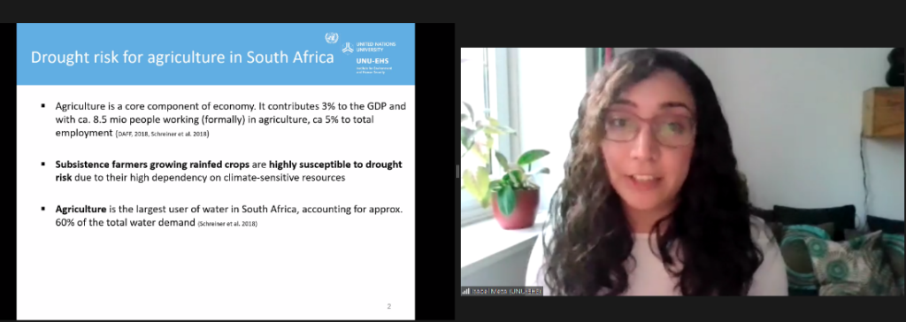
After the keynote, Ms. Isabel Meza (UNU-EHS) gave a presentation about GlobeDrought’s key findings for South Africa.
Key messages:
- Drought is a risk for agricultural systems in South Africa
- Agriculture is a core component of the economy with 5% of employment and a high dependency on climate sensitive resources
- Analysis of agriculture needs to be separated by rainfed and irrigated systems, drought exposure depends on these sectors
- Identification of vulnerability indicators & weights → 44 suitable indicators for rainfed and irrigated systems
- Drought risk and vulnerability varies substantially for rainfed and irrigated systems
- Every municipality has been affected by drought during the last 30 years
- Relevance to consider experts on the assessments
- Coping capacities and socio-ecological susceptibility are key in the level of drought risk. For rainfed crop areas the lack of area equipped for irrigation.
- Risk assessments should be impact/sector-specific
- Need to have a reliable impact-losses database tailored to specific sector
- SA is a highly susceptible country to drought impacts due to its high dependency on climate-sensitive and nature-based resources
- Enhancement of the analysis would be a temporally dynamic exposure and vulnerability analysis, complementing the hazard data
- Drought vulnerability is key for drought risk management. Potential entry points to reduce vulnerability:
- Information access to environmental awareness
- Risk transfer mechanisms (e.g. insurance)
- Soil and land conservation techniques
It was recommended that sector specific impact risk assessments are conducted and on the other hand there is need for moving away from the silo approach, is there a way to harmonise the two seemingly divergent views?
Isabel Meza: It really depends on what specific impacted sector you want to focus on.
Michael Hagenlocher: We need multi-risk assessments, one hazard can have cascading impacts, so we can understand risk from a more comprehensive way.
Andries Jordaan: It is very important to keep it sector specific (irrigation or rainfed).
Group Discussion
In the following session, the participants split into two groups to brainstorm key gaps, challenges and needs as well as potential recommendations around the topics Early Warning, Early Action and Strengthening Drought Resilience.
GROUP 1 – “Early Warning, Early Action”
What are key gaps, challenges and needs for science-based information to foster enhanced Early Warning Early Action in the context of drought?
- Improve information of vulnerability and especially resilience, some farmers never apply for drought support, little things are documented, did much research on vulnerability that we might forgot the people’s resilience
- What are appropriate measures to make systems more resilient?
- Back to validation of data: Validate the results from satellite images, also do the impact assessment, farmers report field conditions, animal conditions etc. in some provinces, one could include apps for those reports
- Timing of drought (end or begin of a season) is important and should be integrated to gain a proper picture
- How to break data down from broader scale to the most detailed level is a challenge
What are potential recommendations for science, practice and policy to ensure risk-informed early warning, early action?
For science:
- Include impact assessment
- Impact based information systems via smart apps from crowd/grass route referencing helping recognition of on-ground impact.
- Need for more focus on more information as well as including resilience in the information systems.
- Move away from municipal boundaries, towards catchment area (as already mentioned in Jordaan’s keynote) to better assess drought situation and avoid skewed pictures of drought
- We need combination of drought indicators for better identification of drought. One overall drought indicator cannot be used for specific areas. Risk and vulnerability drought indicators could be more district level or local areas or at specific risk.
- Compiling data is still linked to municipality and it should be linked somewhere else
- Match our innovations/information feeds to the needs and policy demands in SA
- Could be something to be synced with processing of early warning information systems
For practice & policy:
- Include impact assessment
- Impact based information systems via smart apps from crowd/grass route referencing helping recognition of on-ground impact.
- Use different spatial units, not only stick to one view
- A need to contingency and recovery plans
- Need for increasing Coping capacities at local level
GROUP 2 – “Strengthening Drought Resilience”
What are key gaps, challenges and needs for science-based information to enable communities, sectors and countries to strengthen their resilience to droughts?
- Gap between science and practice: not reaching information to operational level
- Lot of data exists & has been transformed to information, but gap is to get the information to the grassroot (e.g. farmers) where it matters
- Gap at local (municipality level), sometimes are not guided by science
- Lack of drought data, often hard to quantify
- Information does not reach to local level, hard to interpret for some actors
- Adapting technology: How do we need to adapt our technology (e.g. irrigation) to the needs of the people & combine with local knowledge (what are their coping strategies)
- Another challenge is the move from reactive mode to proactive measures (on this the recommendation for policy is build)
What are potential recommendations for science, practice and policy to ensure that drought resilience strategies and actions are risk-informed?
For science:
- Consider local communities on the drought assessments
- Provide recommendations for actions & for policy (how to mode out of response mode)
- Risk communication: Scientists to work on their risk communication to bridge science-practice/policy gap
- Research on how recovering from droughts influences capacities to deal with next event
- More use of adaptive technologies. (case specific adaptive strategies)
For practice & policy:
- Data is key for evidence-based decision making
- More comprehensive data collection e.g. include key vulnerability drivers in panel surveys (e.g. census)
- Need for mind shift and policy shift towards drought preparedness instead of response
- We should decentralise, lower Level People are not very much represented
- Participatory management: Sustainable finances at local level
- Implementation of drought management plans: More policies (e.g. rain harvesting)
- Promote Nature-based Solutions (NbS) for dealing with droughts E.g. maintaining wetlands & better land management
- We Need to manage extremes (heavy rain for harvesting for drought). Look at the two Ends of the spectrum of meteorological extremes
- Drought recovery plan and actions should be as rapid as response to COVID!
How can we overlay this exposure and vulnerability dataset with a hazard dataset?
Andries Jordaan: Can be done if it’s available. We have all the satellite images which is very accurate but resilience and vulnerability remains a challenge, it’s also very dynamic (changes and dynamics in population movement and economic situations, e.g. COVID, two million people lost their jobs in SA), to keep this data updated is not so easy.
Johanes Belle: Response to drought is always very slow, relief came in very late in former droughts, also there’s a slip, people tend to forget about drought once it’s over. This forgetting makes it difficult to deal with the drought.
Wrap-up & Closure
- Drought related information and tools must fit to purpose (sector, scale…)
- Compromises needed to balance accuracy & simplicity, detail & timeliness, extent & resolution
- Focus on resilience: what are the things making systems more resilient? Can this be reflected in indicators to be measured and monitored?
- “One size fits all” will likely not work in future drought response and management
- Gap between science and practice needs to be bridged